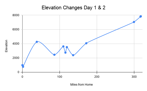
As you may know, travel days lasting more than a few hours require you to occupy your mind. One of my mental diversions this summer was tracking our elevation changes.
In the RV, it is very obvious when you are climbing a hill. You know it’s a climb if there is an added “Slow Vehicle” lane which we usually use. On day 1 we had 2 “major” passes to climb. Cajon Pass is about 10 miles long; Sherwin Summit is about 20 miles.
As you can see, we had plenty of up and downs on day 1. Day 2 was a short drive of .8 miles with a 38 foot elevation gain.
Only variations greater than 500 feet were collected. I used this website for elevations. (https://en-us.topographic-map.com/map-8t6/United-States/)
Links are for your information – we do not receive any compensation for said links to other sites.
Travel Day 1 and 2 Chart
| Location | Elevation Feet above Sea Level | Elevation Change from Previous | Mileage from Home |
|---|---|---|---|
| Home CA | 991 | – | – |
| low point (near home) | 768 | -223 | 1.8 |
| Cajon Pass CA | 4260 | +3492 | 38.7 |
| Kramer Junction CA | 2452 | -1808 | 85.9 |
| Red Hill CA | 3620 | +1168 | 110 |
| near Rand CA | 2751 | -865 | 115.6 |
| near Searles CA | 3518 | +767 | 119.4 |
| near Inyokern Airport CA | 2391 | -1127 | 136.3 |
| near Haiwee Reservoir CA | 4061 | +1670 | 171.6 |
| Sherwin Summit CA | 7045 | +2984 | 299.6 |
| Mammoth Mtn RV Park CA | 7800 | +755 | 317.2 |
| Old Shady Rest Campground CA | 7838 | +38 | 318.0 |


Leave a Comment